CREATE SPATIAL INDEX statement
The CREATE SPATIAL INDEX statement creates a spatial index on a specific graph.
To specify the graph, use either of the following methods:
- Add a USE clause before this statement to set the working graph.
- Use SESSION SET to set the graph for the current session in advance.
If both methods are used, the one specified in the USE clause takes precedence. If neither is used, an error occurs.
You can create a spatial index based on a GEOGRAPHY property of a node type or edge type. Spatial indexes accelerate queries of spatial range, proximity, intersection, and other spatial-related operations.
To create other types of indexes, see CREATE NORMAL INDEX, CREATE VECTOR INDEX, and CREATE FULLTEXT INDEX.
How spatial indexes are implemented
In NebulaGraph Database Developer Edition, the spatial index works as follows:
- Decompose the grid into multiple levels: The entire spatial space of the earth is projected onto a sphere and decomposed into a multi-level grid hierarchy. Each successive level further decomposes the level above it, so each upper-level cell contains a complete grid at the next level.
- Determine the size and the number of the grid cells: The higher the level, the smaller the size of each cell, and the more cells are needed to cover the same spatial object.
- Build the index: The system calculates the grid cells covered by a spatial object and records the mapping between spatial objects and grid cells in the index.
- Query spatial data: The system scans only grid cells that overlap with the target spatial object, quickly locating the target spatial objects.
The following figure shows an example where a space is decomposed into a 4-level 4x4 grid, resulting in a total of 65,536 cells on the 4th level..
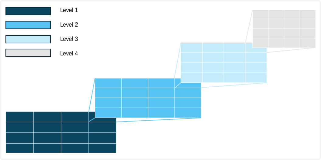
You can refer to the level (the grid level) and average area (the size of each cell) column in S2 Cell Statistics, and configure the parameter s2_max_level and s2_max_cells to optimize the index for your specific use case.
Note
An operation involving a non-default schema or an object in it requires access to the schema, either implicitly or through an explicit USAGE grant, as well as the privilege required for the operation. The schema access check and the privilege check for the requested operation are independent; satisfying one does not satisfy the other. Schema access control does not apply to temporary graphs or built-in procedures and functions. For more information, see Schema access control.
Prerequisites
- A graph is created. For more information, see CREATE GRAPH.
- To create a spatial index, you must either be the owner of the graph, be granted to perform the action
INDEXon the graph, or be granted to perform the actionCREATE INDEXon the used schema. For more information, see Roles and privileges.
Syntax
- create_spatial_index_statement
- spatial_index_configuration
create_spatial_index_statement ::=
    'CREATE' 'SPATIAL' 'INDEX' ('IF NOT EXISTS')? index_name 'ON' ( ( ('NODE' | 'VERTEX') 'TYPE'? node_type_name) | ( ('EDGE'|'RELATIONSHIP') 'TYPE'? edge_type_name) ) '(' spatial_index_configuration ')'

spatial_index_configuration ::=
    'geography_property_name' ',' 's2_max_level' '=' int_value ',' 's2_max_cells' '=' int_value
Parameters
IF NOT EXISTS
This clause checks if an index with the same name already exists. If it already exists, the index is not created and no exception is thrown.
If you do not specify this clause, an exception is thrown if an index with the same name already exists.
index_name
The name of the spatial index to be created. The name is a regular identifier, and must be unique among all types of indexes within the same graph.
For more information, see Rules for naming identifiers.
node_type_name
The name of the node type on which the spatial index is created. The node type must have at least one property of type GEOGRAPHY.
edge_type_name
The name of the edge type on which the spatial index is created. The edge type must have at least one property of type GEOGRAPHY.
spatial_index_configuration
The property based on which the spatial index is created and its index configurations. Only one property can be indexed per spatial index.
geography_property_name
The name of the property to be indexed. The property must be of type GEOGRAPHY.
s2_max_level
The maximum level of the grid that can be decomposed. Higher levels create finer grids with smaller cells, increasing index size and maintenance costs. Valid range: (0, 30].
s2_max_cells
The maximum number of cells a spatial object can be covered. Lower values reduce index records, storage, and query complexity but may decrease index precision. Valid range: (0, 256].
Examples
The following examples are based on the graph my_graph created in How to use spatial data.
Create a spatial index on a node type
USE my_graph CREATE SPATIAL INDEX IF NOT EXISTS idx_gnode_g ON NODE Person(any_geo, s2_max_level = 30, s2_max_cells = 8)
The preceding example creates a spatial index named idx_gnode_g on the node type Person for the property any_geo, with a maximum grid level of 30 and up to 8 covering cells.
Create a spatial index on an edge type
USE my_graph CREATE SPATIAL INDEX IF NOT EXISTS idx_gedge_g ON EDGE GEdge(company_location, s2_max_level = 30, s2_max_cells = 8)
The preceding example creates a spatial index named idx_gedge_g on the edge type GEdge for the property company_location, with a maximum grid level of 30 and up to 8 covering cells.